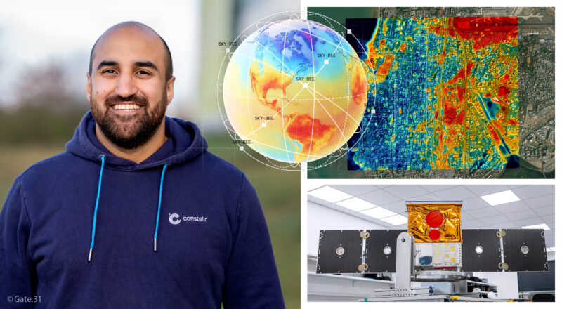
A meeting with Mohammad Iranmanesh, Director of constellr’s Belgian entity.
It was in Brussels that we met Mohammad Iranmanesh for a fascinating discussion about the activities of constellr. The company operates a constellation of microsatellites to collect high-precision thermal data of the Earth’s surface. To date, constellr employs around one hundred people, based in Germany (headquarters), France, and Belgium.

From agriculture to defense…
Let us take the example of plants: leaf temperature makes it possible to detect water stress situations at an early stage and to act before the effects become visible or irreversible. This first example is no coincidence. Since its inception, constellr has set itself the goal of becoming a key player in the sustainable management of natural resources (land and water) by leveraging thermal intelligence.
Initially developed for precision agriculture, constellr’s technology has gradually expanded to other fields of application. Today, it is used to detect urban heat islands, as well as for defense-related purposes. In this context, thermal analysis makes it possible to detect and characterize abnormal or emerging activities, for example at sensitive sites such as nuclear facilities or strategic industrial complexes.

A third satellite soon in orbit
To date, constellr operates two satellites. These latest-generation microsatellites orbit in a sun-synchronous orbit at an altitude of 510 km. Each satellite is equipped with a thermal infrared camera as well as a VNIR spectrometer, delivering spatial resolution down to 10 meters and thermal accuracy on the order of 1 to 2 kelvins. This instrumental combination enables the production of very high-quality thermal and spectral data.

The HiVE (High-Precision Versatile Ecosphere) constellation thus measures absolute land surface temperature with unprecedented accuracy and provides near real-time global temperature mapping. By the end of 2026, a third satellite will strengthen this constellation. The deployment of this third satellite, along with those that will follow, will support defense-related activities, thanks to improved revisit times and image resolution that will continue to advance over the coming years.

How does constellr stand out from other Earth observation players?
What sets us apart from other players is precisely our use of LWIR (Long-Wave Infrared) thermal imaging. This technology makes it possible to measure absolute surface temperature as well as very small temperature variations, both day and night, provided atmospheric conditions allow it (i.e. in the absence of cloud cover).
Unlike many actors that rely on indirect data or derived thermal estimates, constellr directly measures the thermal signal. This approach ensures a particularly high level of accuracy and reliability for applications requiring fine analysis of surface dynamics. In addition, constellr controls the entire value chain, from the space instrument (satellites and sensors) to data processing and distribution. This end-to-end approach not only optimizes data quality and consistency, but also provides end users with fast, actionable access tailored to their operational needs.
What role does the Belgian operation play in constellr’s European strategy?
The Belgian operation holds a central position in constellr’s European strategy. Today, the data collected by the two instruments aboard the SkyBee-1 satellite (VNIR spectrometer and LWIR thermal infrared camera) are processed, enriched, and leveraged via a cloud-native platform and an advanced processing chain – both developed and operated from Belgium.
The Belgian hub thus serves as constellr’s analytical and software core in Europe. It concentrates expertise in high-precision thermal data processing, the integration of biophysical models, and the deployment of advanced analytical algorithms powered by artificial intelligence. This approach transforms raw satellite data into actionable, accessible, and high-value insights for end users.
« constellr’s goal is clear: to create a global thermal atlas. By combining ultra-precise proprietary data with biophysical models and AI-enhanced analyses, constellr and constellr Belgium will deliver reliable thermal information in near real-time. » – Mohammad Iranmanesh
In the face of global climate and food challenges, what role do you hope to play in the coming years?
Food security has always been at the heart of constellr’s mission, it’s in our very DNA! From the start, our technologies were designed to help the agricultural sector better understand crop conditions and optimize the use of natural resources.
This mission becomes even more critical as pressure on global food systems intensifies. The world population is expected to reach nearly 10 billion by 2050, leading to an estimated 60% increase in food demand. At the same time, agriculture already accounts for nearly 70% of global freshwater withdrawals.
Democratizing access to ultra-precise thermal data would make sustainable land and water management easier. Our goal is to help build more resilient agricultural systems, capable of meeting food security challenges while preserving natural resources.
With the expansion of the HiVE constellation and its international ambitions, how does constellr reconcile growth with European sovereignty?
The question of sovereignty is central, particularly regarding strategic and Earth observation data. constellr fully embraces this approach. Although our clients are located worldwide, we have made the strategic choice to keep our key operations – R&D, data processing, and hosting – in Europe.
This organization ensures European sovereignty while allowing constellr to expand internationally.
Your space-based thermal imaging technology offers unprecedented precision. What are the key innovations – sensors, data processing, AI – that make constellr stand out today?
constellr stands out thanks to the quality of its thermal measurements. Our LWIR infrared sensors allow for direct and precise measurement of surface temperature. This measurement is enhanced by a hybrid approach combining physical models and artificial intelligence, enabling the production of high-resolution, reliable thermal maps. AI is also used to fuse our data with that from other space missions, to estimate temperatures in areas not directly observed, and to provide ‘analysis-ready’ products that are immediately usable by end users.
And what about the future?
In the coming years, constellr will deploy and operate its HiVE constellation on a global scale to provide high-precision thermal intelligence, revealing system conditions, activity dynamics, and behaviors. The goal is to strengthen European autonomy by filling a critical gap in absolute thermal observation capabilities from space.
